
- An area of forest larger than England could be cleared by 2050 in one of the best-preserved parts of the Brazilian Amazon, a new report warns.
- It says the main drivers of deforestation in the Middle Purus region of Amazonas state are illegal logging, neglect by government institutes, and the paving of the BR-319 road.
- The Middle Purus region is home to two areas where isolated Indigenous people were recently discovered, the Jacareúba-Katawixi Indigenous Territory and the Mamoriá Grande River region, but both have been without formal protection since temporary decrees were allowed to expire last year.
- The road-paving project, revived by the Bolsonaro administration in 2020 after being shelved in 1988, also threatens a surge in the deforestation rate, giving land grabbers and illegal loggers greater access to previously remote areas of forest.
The central Purus River Basin is one of the best-preserved regions of the Brazilian Amazon. But deforestation here, in the state of Amazonas, could clear an area larger than England by 2050, according to a new report by several civil society organizations.
“The region of the Middle Purus has a series of Indigenous territories, extractive reserves [Resex] and national forests that are connected to each other, forming large mosaics of protected forests,” says Antonio Oviedo, the monitoring program coordinator for Instituto Socioambiental (ISA), one of the groups behind the report for the “Isolated or Decimated” campaign.
The report estimates that deforestation in the Middle Purus region will reach 170,000 square kilometers (65,600 square miles) by 2050. That’s an average of 9,400 km2 (3,630 mi2) of devastation per year, a rate close to the 10,000 km2 (3,860 mi2) recorded for the entire Brazilian Amazon in 2019.
The report identifies how deforestation, illegal occupation of public lands, and logging are already threatening parts of the Middle Purus, including protected areas:
- Middle Purus Extractive Reserve: This area has suffered intense activity from land invaders and illegal loggers since 2017, according to the report. Between August 2021 and January 2022, more than 27,000 mature trees were cut down within the reserve.
- Ituxi Extractive Reserve: Located between the Middle Purus Resex and the Jacareúba-Katawixi Indigenous Territory, home to a population of isolated Indigenous people, deforestation has been increasing inside the Ituxi Resex since 2017. The forest clearing peaked in 2021, when the rate was 373% higher than in 2020. Satellite monitoring also shows that the region suffers from illegally set fires.
- Iquiri National Forest: This area was created to promote sustainable forest management in the area of influence of BR-319, a federal road that cuts through the Amazon Rainforest, connecting Manaus to Porto Velho. However, between 2019 and 2021, deforestation in the national forest saw the equivalent of 5.9 million mature trees felled.
The conservation units cited are located in the municipality of Lábrea in Amazonas. The region recorded about 450 environmental violation notices in the past three years, according to data collected by Mongabay from IBAMA, the Brazilian environmental protection agency.
According to the IBAMA report “Diagnosis of Environmental Crimes,” the most frequent fines in 2021 were issued for the conversion of native vegetation into pasture “by means of chainsaws, use of fire and heavy machinery, promoted by farmers and landowners in Indigenous Lands and Federal Conservation Units.” Another common violation was illegal logging, typically masked with the use of falsified documents for domestic and export sales, and the “unauthorized cutting of trees, even in protected areas to supply lumber companies, often clandestinely.”
A study by the Amazon Environmental Research Institute (IPAM) published last November shows that 54% of the deforestation recorded between January and October 2021 in the Amazon occurred on public lands. That’s up from 44% between 2019 and 2020.
The “Isolated or Decimated” report says the combination of illegal occupation of public lands in the Middle Purus region, setbacks in policies to protect isolated peoples, and plans to pave the BR-139 highway will worsen the devastation in the region.
No protection for isolated tribes
The Middle Purus region is home to groups such as Indigenous people living in voluntary isolation, traditional populations, and riverside communities.
But an unraveling of protections for isolated Indigenous people specifically “can generate new genocides and degrade areas that are already legally protected,” the new report says.
It report refers to the Jacareúba-Katawixi Indigenous Territory and the recently discovered isolated groups in the region of the Mamoriá Grande River, in Lábrea. A decree from Funai, the federal agency for Indigenous affairs, previously protected both areas from natural resource exploitation activity as well as the movement of people other than the isolated groups and experts authorized by Funai. But that decree expired at the end of last year, and hasn’t been renewed since.
Identified in 2007, the Jacareúba-Katawixi isolated peoples have been “under study” by Funai for almost 15 years. Without formal demarcation, the territory depends on temporary decrees being issued to protect it. The last decree, published in 2017, expired in December 2021.
Oviedo says Funai should be tackling the issue urgently, since deforestation inside the Jacareúba-Katawixi territory increased by 60% in 2021 — and that was at a time when the territory was still ostensibly protected under Funai’s land use restriction decree.
In addition to the deforestation, the Indigenous territory is also subject to applications for gold prospecting. Applications filed with the National Mining Agency (ANM) in 2020 alone cover some 12 km2 (4.8 mi2) inside the territory. There are also 639 properties or farms registered by invaders in the Jacareúba-Katawixi territory through the self-reported Rural Environmental Registry, threatening more than 600 km2 (230 mi2) of land in the reserve, according to the report. The registry is a controversial system frequently used by land grabbers because it allows anyone, even those without a license or registration of a rural property, to apply for ownership of an area.
As of July 2021, there was nearly 59 km2 (23 mi2) of deforestation inside the Jacareúba-Katawixi Indigenous Territory, according to PRODES, the Brazilian space agency’s program for monitoring primary forest deforestation in the Amazon. That corresponds to more than 3 million felled trees, according to the report.
Data from IBAMA seen by Mongabay show that, in the part of the territory that lies within the municipality of Canutama, 112 environmental infraction notices have been issued since 2019.
Mongabay asked Funai about the failure to renew the protective decree for the territory, as well as the delay in the demarcation process; less than 30% of the process has been completed since 2007. “About the Jacareúba-Katawixi area, Funai informs that the theme is under analysis,” the agency replied in a statement.
Yet Funai itself has declared that the demarcation of Indigenous lands is one of the main impediments to the privatization of public lands, since property titles cannot be issued for these territories. Brazil’s Constitution of 1988 considers Indigenous people the first and natural owners of the territory, and makes it incumbent on the state to demarcate all the lands originally occupied by these populations.
Brazil has more than 300 Indigenous territories that are still in the process of demarcation. This number doesn’t include the isolated Indigenous groups.
Inaction from Funai
The report also shines a light on the isolated people who live in the Mamoriá Grande River region of the Middle Purus Extractive Reserve. The group was discovered by a team from Funai’s Lábrea Protection Front in September 2021. Researchers immediately sent the first report to Funai about the existence of the isolated group, but no action was taken.
According to the Indigenist Missionary Council (CIMI), a Catholic Church-affiliated group that advocates for Indigenous rights, two other reports on the isolated peoples of Mamoriá Grande have been sent to Funai, requesting emergency measures in the face of intensifying deforestation and invasions in the region. Funai has taken no measures so far on these points.
Oviedo says Funai should have issued a land use restriction decree, in addition to establishing protection bases to control and monitor access to the region, as invaders could bring COVID-19 to the isolated people and decimate them, since they don’t have access to vaccines or immunity to many common infectious diseases.
“Emergency and continuous measures for the removal of invaders from the Jacareúba-Katawixi Indigenous Territory and [other] conservation units located in the Middle Purus region, which can spread COVID-19 and provoke the genocide of Indigenous peoples and, above all, of isolated groups, remain indispensable,” the “Isolated or Decimated” report says.
It also notes that there are 1,165 km2 (450 mi2) of self-declared properties inside the extractive reserve filed with the Rural Environmental Registry.
Asked about why it still hasn’t issued a land use restriction decree for the isolated people of Mamoriá Grande, Funai said more studies about the group are needed. It has “analyzed the reports about the possible existence of a group of isolated Indigenous people in the Himerimã area, in Amazonas,” the agency said in a statement. “However, only with the continuity of the studies and monitoring actions will it be possible to clarify issues related to the occupation of the area.”
Paving of BR-319
Oviedo says the Middle Purus remains one of the best-preserved regions in the Brazilian Amazon because it has no roads.
“The level of preservation in the Middle Purus region today is very high, especially in the Purus and Juruá river basins, because there is no road there yet, and the road is a vector for deforestation,” he says.
The report quotes studies showing that 95% of the accumulated deforestation in the Amazon is concentrated within 5.5 km (3.4 mi) of a road. Similarly, 85% of fires also occur within this band, indicating the impact that the BR-319 paving could have on the region.
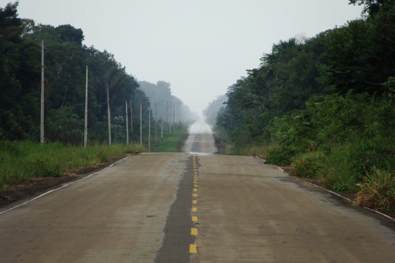
BR-319 is an 885-km (550-mi) federal road conceived during Brazil’s military dictatorship (1964-1985) to connect the states of Amazonas and Rondônia. After being abandoned in 1988, the paving of the road was resumed under the government of the current president, Jair Bolsonaro, in 2020, when a public bidding notice was published to pave the first stretch.
The “Isolated or Decimated” study shows that, between 2015 and 2020, even without BR-319 being paved, the average annual deforestation rate in Amazonas was 1,150 km2 (444 mi2). With the paving of the road, this rate could surge nearly nine times higher, it warns.
With the paving, and with a more permissive climate such as that engendered by a bill currently in Congress that would loosen environmental licensing requirements, “a significant increase in deforestation is predicted, which may reach 9,400 km² per year in 2050 in the state of Amazonas,” the report says.
The legislation in question, Bill 3.729/2004, would scrap the requirement that projects undertake an impact analysis and adopt measures to prevent damage to Indigenous territories that have not been demarcated. It would also no longer require analysis of indirect impacts on conservation units from projects.
Oviedo says that even without any roads connecting the Amazon to the rest of the country, the Middle Purus region is already suffering from invasions by deforestation through its water network.
“Besides the environmental devastation caused by the project itself, the BR-319 road will open new deforestation frontiers within the forest that is currently preserved,” he says. “The Middle Purus region will be more easily accessed by invaders.”
Banner image of the BR-319 road. Image courtesy of the National Department of Transport Infrastructure (DNIT).
This story was reported by Mongabay’s Brazil team and first published here on our Brazil site on March 14, 2022.